CCIM + STDB Webinar Recap: The Fastest Path from CRE Research to Opportunity
Discover how ParGo AI's geospatial intelligence transforms CRE property analysis, speeding up research and uncovering opportunities in minutes. Learn...
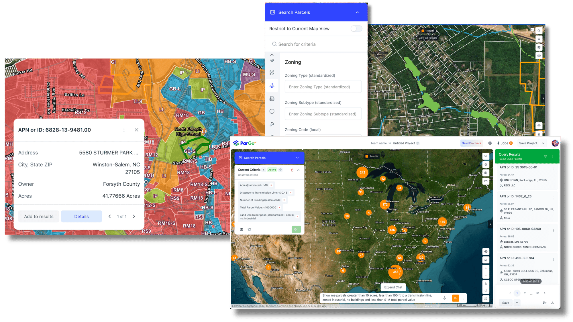
Plan growth, monitor development, and attract investment with unified parcel, zoning, permit, and market intelligence, delivered through one intuitive, AI-powered platform.
Track permits, construction activity, and land-use changes across your jurisdiction in near real time—without waiting for quarterly reports.
Analyze zoning, land coverage, ownership, and infrastructure at the parcel level to support smarter land-use and redevelopment strategies.
Equip leadership, councils, and investors with clear, defensible insights grounded in verified property and market data.
Looking for some ideas of ways that ParGo could assist in your existing workflows?
Visualize new permits, renovations, and construction trends by neighborhood or corridor.→ Identify growth hot spots, stalled areas, and infrastructure pressure points.
Instantly evaluate existing zoning, allowable uses, and land coverage across parcels.→ Support rezoning studies, comp plans, and entitlement reviews with data.
Identify underutilized parcels, vacant land, or aging properties suitable for redevelopment.→ Prioritize sites for infill, mixed-use, or economic revitalization initiatives.

Looking for some ideas of ways that ParGo could assist in your existing workflows?
Quickly surface development-ready sites that meet investor or employer criteria.→ Respond faster to RFPs and site-selection requests with confidence.
Understand who owns key parcels—including LLC-controlled properties.→ Improve outreach, coordination, and public–private collaboration.
Monitor how zoning changes, incentives, or infrastructure investments influence development patterns over time.→ Measure the real-world impact of policy decisions.


1 - Map your jurisdiction. Draw districts, corridors, or opportunity zones.
2 - Analyze activity and capacity. Filter by land use, coverage, or permit type.
3 - Share and act. Generate reports or maps for leadership, councils, or partners.
Discover how ParGo AI's geospatial intelligence transforms CRE property analysis, speeding up research and uncovering opportunities in minutes. Learn...
| Category | Sample Insights |
|---|---|
| Parcel & Ownership | Parcel boundaries, LLC resolution, mailing addresses, true owners |
| Zoning & Land Use | Current zoning, allowable uses, density, and constraints |
| Permits & Construction | 20+ years of permit data by type, value, and contractor |
| Environmental & Planning Layers | Flood zones, constraints, and infrastructure context |
| Market & Investment Signals |
Sales activity, redevelopment trends, vacancy indicators |
| Change Detection | New permits, ownership transfers, and regional construction surges |
“What took us 3 months now takes us 3 minutes.”
“We have been waiting for a solution to come along that does half of what ParGo can do.”
“We will be spinning up a division to leverage the possible use cases that ParGo data opens for us to expand into new areas.”
Unified planning intelligence: Parcels, zoning, permits, and ownership in one system
Change detection & monitoring: Continuous intelligence for land, construction, and market shifts.
AI-assisted analysis: Ask complex planning questions in plain language
Real-time visibility: Monitor development activity as it unfolds
Scalable and cost-effective: Enterprise-grade insight without enterprise complexity
Cross-department alignment: Planning, economic development, and infrastructure teams working from the same data
Yes. ParGo is used by planning, infrastructure, and economic development teams to support zoning analysis, development monitoring, and site readiness without requiring GIS expertise.
Absolutely. ParGo enables teams to quickly identify and package development-ready sites with zoning, ownership, and infrastructure context—reducing response time from weeks to minutes.
By analyzing permit trends, land coverage, and redevelopment patterns over time, ParGo helps planners understand where growth is occurring and where policy adjustments may be needed.
No. ParGo complements existing GIS tools by providing faster analysis, AI-powered insights, and easy-to-share outputs that integrate with your current workflows.
Use permit history and activity alerts to understand when borrowers are improving, or neglecting, their collateral.
→ Monitor property condition and borrower investment behavior.