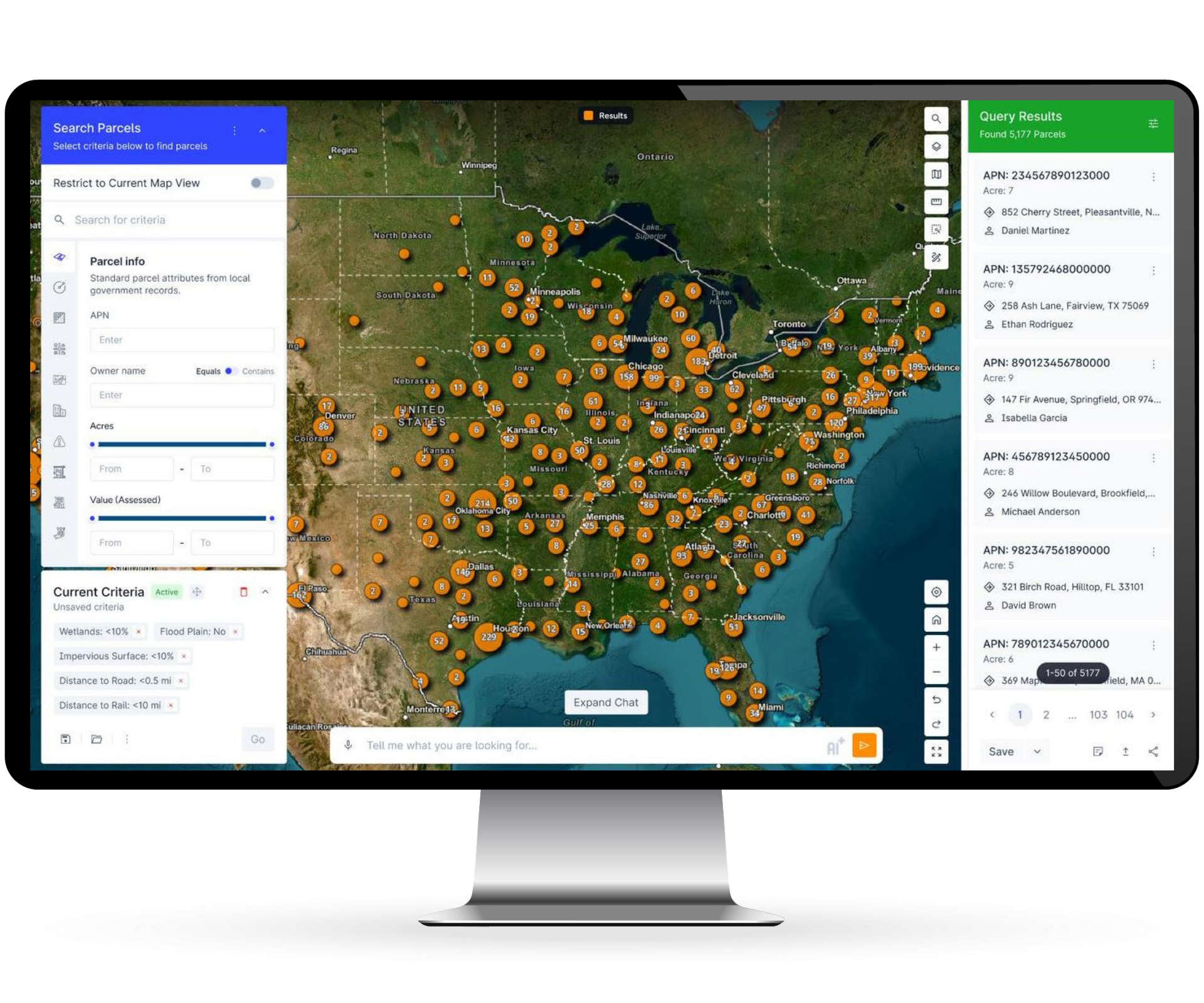
POWERFUL PRODUCT

One Tool for Property Insights

Use ParGo to access the data you need, complete complex analyses with ease, and build your market intelligence advantage. Analyze more deals, find more opportunities, and save more time.  

POWERFUL WORKFLOWS

Leverage Advanced Analytics Instantly 

OWNERSHIP TRACING

MARKET LISTINGS

CHANGE DETECTION

SITE SELECTION

LEAD GENERATION

PARCEL ENRICHMENT
LAND USE
PROPERTY EVALUATION

MARKET INTELLIGENCE

DUE DILIGENCE

PORTFOLIO MANAGEMENT

OPPORTUNITY SIGNALS
POWERFUL FEATURES

Access Premium Professional Tools

Nationwide Queries

pargo_comp

Spatial & Tabular

Search every parcel in the US by thousands of different attributes. Use criteria like distance to features, distance from features, intersecting features, land coverage percentages, and more. 

GeoSpatial Integration
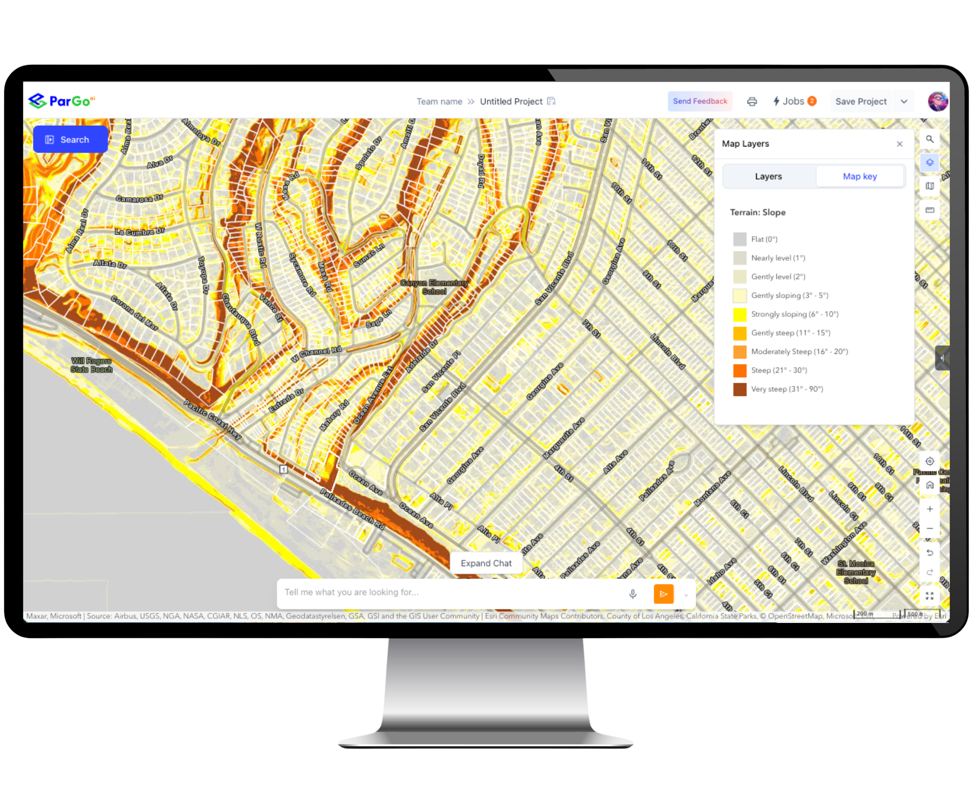
PG App Screens

GIS Technology

Leverage location analytics and Geographic Information Systems (GIS) in your property workflows. Import and export with Esri ArcGIS, analyze proximity and assess coverage. 

Reporting & Exporting

PG App Screens (3)

Extract Critical Data

Export the data you need in the formats you need. From creating single property PDF reports and maps, to exporting bulk property records as a spreadsheet, you can easily take your property data with you. 

Ownership Tracing

PG App Screens (2)

Discover True Owners & Contact Info

Pierce the corporate veil to find the true owners of property behind listed corporate entities. Return contact information for owners including phone, email and websites with AI deep research.

Parcel Enrichment

PG App Screens (4)

Enrich Your Data

Bring your data in through file uploads, ArcGIS integration or web links. Then enrich this data with the underlying parcel information to enhance your property intelligence.

API Access

PG App Screens (5)

Automate Your Data Retrieval

Leverage the API to create regularly scheduled retrievals of parcel information. Enrich your property CRM, procure data for advanced analytics, and feed intelligence into your workflows. 

pargo_comp

Spatial & Tabular

Search every parcel in the US by thousands of different attributes. Use criteria like distance to features, distance from features, intersecting features, land coverage percentages, and more. 

PG App Screens

GIS Technology

Leverage location analytics and Geographic Information Systems (GIS) in your property workflows. Import and export with Esri ArcGIS, analyze proximity and assess coverage. 

PG App Screens (3)

Extract Critical Data

Export the data you need in the formats you need. From creating single property PDF reports and maps, to exporting bulk property records as a spreadsheet, you can easily take your property data with you. 

PG App Screens (2)

Discover True Owners & Contact Info

Pierce the corporate veil to find the true owners of property behind listed corporate entities. Return contact information for owners including phone, email and websites with AI deep research.

PG App Screens (4)

Enrich Your Data

Bring your data in through file uploads, ArcGIS integration or web links. Then enrich this data with the underlying parcel information to enhance your property intelligence.

PG App Screens (5)

Automate Your Data Retrieval

Leverage the API to create regularly scheduled retrievals of parcel information. Enrich your property CRM, procure data for advanced analytics, and feed intelligence into your workflows. 

POWERFUL DATA

Uncover Comprehensive & Reliable Data

Parcels

Every property parcel in the US with updates monthly. CAN and EUR coming soon...

Ownership

Property owners and mailing addresses, as well as skip tracing for more info.

Permits

20 years of permit history including permit types, values, and date ranges.

Construction

Construction periods for properties based on permitting and activity.

Mortgage & Liens

Assignments, releases, liens, loans, and other financial recording documents.

Distressed

Foreclosures, pre-foreclosures, probate, pre-probate, divorce and more.

Comparisons

Comps for rent, sale and lease across all asset types and classes.

Zoning & Use

Standardized zoning nationwide and local zoning codes with specified rules.

Demographics

Population, income, growth, behavior, spending, psychographics and more.

Business

Business locations, classifications, names, opportunity zones and additional info.

Environment

Wetlands, flood plains, soils, slope, and land coverage percentages by type.

Listings

On-market listings and details, with direct linking to brokerages and agents.

Human Movement

Mobile device movement captured by time and location, with home location attribution.

Traffic

Live traffic and traffic incidents, along with average annual daily traffic counts (AADTs).

Energy & Utilities

Major utility locations and characteristics, including proximity to properties.

POWERFUL INTELLIGENCE

Discover The Location Advantage of AI

  • 🌎 GeoAI

  • 🔎 Detection AI

  • 💬 Suggestive AI

  • 🔮 Predictive AI

Detect | Suggest | Predict

Use GeoAI to find patterns in the landscape, from detecting land coverage across all parcels, to finding new building areas. Predict sales, development pro-formas and more. Suggest and perform advanced analytics easily, using only your voice and natural language. Work smarter with ParGo AI.

Imagery to Intelligence

Deep learning and imagery detection allows you to detect land coverage by type across every parcel. Search by coverage specifics including percentages on the property and find new features such as development activity.

Learn and Leverage

ParGo AI will learn from your use of the system, the types of searches you perform, and the data you uncover. You will be guided to more workflows, better criteria, and other ways to enhance your analytics. 

Modeling for Money

Creating predictive models for performance metrics like revenue or sales used to take dozens of hours. With AI you can now model a development pro-forma, predict business revenue, or better understand performance metrics within minutes.