Releases
Whats New in ParGo AI (V3.0 Release)
ParGo AI's Version 3.0.0 release delivers a refined user experience, intuitive AI guidance, and a new map measurement tool that enhances spatial...
ParGo V3.1.0 is designed to help you work faster and get more from your parcel data with powerful new annotation capabilities, a smarter details experience, export upgrades, and a cleaner interface.

ParGo V3.1.0 is designed to help you work faster and get more from your parcel data with powerful new annotation capabilities, a smarter details experience, export upgrades, and a cleaner interface. This release focuses on real workflow gains, making spatial analysis easier, parcel review more informative, and output more reliable.
ParGo V3.1.0 is designed to help you work faster and get more from your parcel data with powerful new annotation capabilities, a smarter details experience, export upgrades, and a cleaner interface. This release focuses on real workflow gains, making spatial analysis easier, parcel review more informative, and output more reliable.
Why it matters: The faster you can move from question to validated parcel insight, the easier it is to deliver confident recommendations and keep projects moving.
V3.1.0 brings a set of updates focused on helping teams work more efficiently inside ParGo. From a new annotation tool to improved exports and a more informative parcel details panel, the release is designed to shorten the time between identifying an area of interest and producing high-quality outputs.
Alongside new capability, the interface has been refined to feel cleaner and more intuitive. These improvements support both new users getting oriented quickly and experienced users moving through complex workflows with fewer clicks.
Why it matters: Spatial analysis often starts with a custom geography. When you can define it in seconds and immediately enrich parcels inside it, you accelerate targeting, evaluation, and reporting.
With V3.1.0, ParGo introduces a new annotation tool that lets you draw custom polygons directly on the map. This enables you to define any region of interest, from a corridor and trade area to a redevelopment zone or site radius, in a way that matches how you think about projects.
Once your polygon is drawn, you can enrich parcels that fall within the boundary and surface the underlying parcel data. This creates a faster and more intuitive workflow for spatial analysis across targeted regions, without the manual effort of selecting individual parcels.
Why it matters: Parcel data can be dense. When critical dates and record types are visible immediately, users can evaluate risk, activity, and context faster with fewer mistakes.
The parcel details panel has been significantly upgraded in V3.1.0. Instead of requiring deeper clicks to locate foundational metadata, key information is now presented directly in the interface, making it easier to interpret what is happening on a parcel quickly.
Combined with improved sorting and clearer identification of associated records, the details experience supports faster review and stronger decision-making. Whether you are validating activity, checking timelines, or assessing documentation, the updated panel helps you move through complex parcel histories with more confidence.
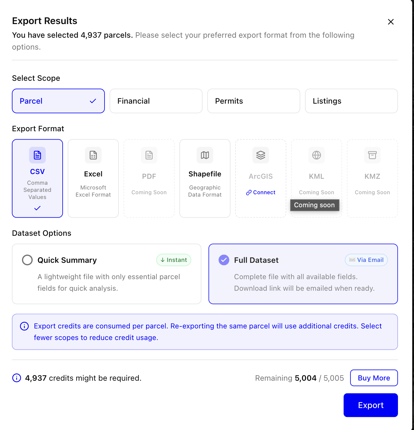
Why it matters: Analysis is only useful if it can be shared and reused. Reliable exports and consistent field definitions make it easier to deliver results and integrate insights into broader reporting.
V3.1.0 includes meaningful improvements to the export system, resulting in faster, dependable exports. This helps teams spend less time waiting for downloads and more time acting on insights.
The data dictionary has also been enhanced to align better with organization-level data standards. Clearer field definitions reduce confusion, improve consistency, and make it easier for teams to collaborate across projects and reporting requirements.

Why it matters: Small interface improvements add up. Cleaner navigation reduces cognitive load and helps teams stay focused on the work, not the UI.
V3.1.0 includes refinements across navigation that make the platform feel simpler and more intuitive. Dropdown menus have been cleaned up, redundant options have been removed, and overall interaction patterns are more predictable.
The user profile menu has also been reorganized to provide a cleaner, more consistent experience. These updates may look subtle, but they remove friction from everyday workflows and help users move through tasks with fewer distractions.
Want to see how V3.1.0 improves spatial analysis, parcel review, and exporting in practice? Schedule a demo to explore the new annotation tool and the upgraded parcel details experience in your market.
For more information or to request access, visit www.ParGoAI.com. We look forward to showing you how ParGo is transforming the future of property intelligence.
ParGo AI's Version 3.0.0 release delivers a refined user experience, intuitive AI guidance, and a new map measurement tool that enhances spatial...
We’re excited to share the latest updates in ParGo AI 2.0.1. This release introduces a powerful new research assistant, adds commercial rent and...
ParGo AI is excited to announce its participation in the CCIM Institute’s 2025 Fall Forum, to highlight how ParGo’s AI-driven platform can empower...